
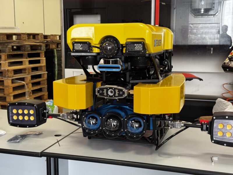
BlueDepth3D 300
BlueDepth3D 300 is a compact underwater multi-camera imaging system designed for accurate georeferenced data acquisition in scientific surveys, industrial inspections, and environmental monitoring missions. Combining stereo and mono optical sensors, it captures RAW imagery optimized for photogrammetry and advanced analytical workflows, enabling high-precision 3D reconstructions and visual analysis of underwater sites and assets.
Integrated in an opto-acoustic robotic platform, BD3D-300 extends the capabilities of ROVs, AUVs and surface vehicles with stable, repeatable high-quality visual documentation across long-duration missions.
Applications
Underwater archaeology – high-resolution 3D photo and video documentation of submerged sites and artefacts, fused with acoustic morphobathymetry for complete geometric reconstructions of cultural heritage assets.
Industrial inspection – detailed visual surveys of infrastructure, pipelines, cables, and subsea assets, supporting condition assessment, corrosion monitoring, and maintenance planning.
Environmental monitoring – habitat mapping and ecological observation missions.
Robotic platforms – imaging payload for ROVs, AUVs, and surface vehicles.
Features
- High‑precision stereo imaging
The stereo camera configuration delivers accurate spatial measurements and depth perception, enabling dimensionally correct 3D reconstructions without the need for extensive scale bars or ground control points. This directly supports metric analyses for archaeology, asset inspection, and ecology, where reliable scale and geometry are critical. - RAW image acquisition for scientific workflows
BD3D‑300 captures RAW imagery to preserve full radiometric information, maximizing photogrammetric fidelity and supporting robust colour management, reflectance studies, and analytical post‑processing. This ensures that datasets remain suitable for advanced scientific workflows, from SfM reconstruction to machine‑learning‑based habitat and defect classification. - Modular system architecture
The system is designed for seamless integration with acoustic positioning solutions, navigation sensors, and additional payloads such as multibeam echosounders and laser scanners. This modular architecture enables comprehensive opto-acoustic survey configurations, where precise bathymetry and high‑resolution imagery are acquired and fused into a single, georeferenced data product. - Compact, robust mechanical design
BD3D‑300’s compact housing simplifies installation on ROV and survey frames while maintaining optical stability underwater. It is depth-rated to 300 m, with an alternative 1000 m version for operations in deeper water. The mechanical design is engineered for long‑duration missions, providing consistent image quality under variable depth, current, and visibility conditions typical of offshore and coastal operations. - Long‑duration mission support
The system architecture and data workflows are optimized for extended survey and inspection campaigns, delivering continuous, high‑quality visual documentation suitable for trend analysis and historical baselines. This makes BD3D‑300 ideal for recurring inspection programs, environmental monitoring time‑series, and multi‑campaign research projects.
No certifications available.
| Categories | Conservation Tools, Energy-Efficient Underwater Vehicles |
|---|---|
| Seller | marco3dr |